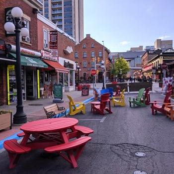
Dorset Scenic Lookout Tower
Climb the 142 metres (465 feet) to the observation deck for an incredible view of the Lake of Bays. There are also picnic sites, restrooms, a tourist information kiosk, a gift shop, and a hiking trail.
The Miss Marie is a wonderful day or evening boat cruise tour experience in Sault Ste. Marie. The Miss Marie operates from early May to mid-October vessel is a 2-hour or evening waterfront boat cruise along the waters of Lake Superior and the St. Marys River. A great experience for everyone.
Point of Interest #3 on the Explorers Snow Tour is the old Purdy Mica Mine. Bring a flashlight and leave your helmet on—it can get pretty slippery in the winter. You’ll find it on the A112A OFSC snowmobile trail. It’s very well signed as it lies on the boundary between the North Bay Snowmobile Club and the Mattawa and Area Snowmobile Club. It’s also located on private property, so practice proper trail etiquette—pack out what you pack in.
At first glance, the small log building situated on Mattawa’s Explorer’s Point seems unassuming—especially since it’s dwarfed by a 16-foot carved wooden statue of the town’s folk hero, Big Joe Mufferaw, standing just outside. But walk through the doors of the Mattawa & District Museum and you've just entered a treasure chest of historic wonders.
The Chief Commanda II is a 320-passenger, all-aluminium twin-hull vessel that cruises at a speed up to 13 knots or 25 km/h. The ship is equipped with two bars, handicap accessible washrooms, snack bar, and open-air BBQ. There are 5 cruises, ranging from 1.5 hours to 4.5 hours.
The Marathon Superior Picnic table is located at the top of Marathon’s famous Pebble Beach, near the parking area. Directions: Take a right out of the Station Four on the North Shore parking lot. Follow Peninsula Road south to the end, take a left on Stevens Avenue, then right on Howe Street to the end. After your picnic, to get right onto the beach follow the short but steep incline to the left.
The Terrace Bay Superior Picnic table is located on the far end of Terrace Bay Beach, directly on the sand, at the end of the boardwalk. Directions: Turn right out of the Drifters parking lot, turn left off highway 17. The turn is indicated by a large, colourful sign. Follow the blue signs down to the beach, about 3 km.
The Schreiber Superior Picnic table is located at Schreiber Beach. After your picnic, enjoy a short hike along a portion of the Casque Isles Trail to the Parks Canada Red Chairs. Directions: Turn right out of the Golden Rail parking area onto the highway, and make an immediate right onto Winnipeg St. At the end of the street, turn right onto Scotia St. and left on Subway St. Follow the signs to the beach, turning right after going under the railway bridge, about 2 km.
The Nipigon Superior Picnic table is located at the marina alongside the majestic Nipigon River, with a view of the Nipigon River Bridge. Directions: Once at the marina, go straight following the signs to the picnic area. The table is at the far end of the marina, near the accessible paddle docks.
The Red Rock Superior Picnic table is located on the breakwater wall at the Red Rock Marina, overlooking Nipigon Bay on Lake Superior. Directions: Turn into the marina at the Red Rock Marina sign. Park at the Interpretive Centre, and follow the path to the right to the end of the break wall.